On the south coast of South Africa, in sediment from a rockshelter near Mossel Bay, there are fragments of volcanic glass too small to see without a microscope, and sparse, roughly one grain in every 10,000. Their chemistry matches an eruption in Sumatra, about 9,000 kilometres away, roughly 74,000 years ago. The people who used that shelter were there before the ash arrived, and they were there afterwards.
That single detail holds most of what makes Toba interesting. The glass shows how far the ash travelled. It works as a time marker that scientists can match from cave floors to lake beds to polar ice. And it is one of the pieces of evidence that has undermined a famous claim: that the eruption nearly ended our species.
So there are two stories here. One is about an eruption we can reconstruct in remarkable detail. The other is about an idea that was built on that eruption, and then tested against better evidence than anyone had when it was proposed. Follow the ash far enough and you reach both.
A lake in the shape of a collapse
Start at the source. In northern Sumatra, a depression about 100 kilometres long and 30 kilometres across holds Lake Toba, which is more than 500 metres deep. Steep, dissected highlands ring it.
The basin is a caldera. That's the word for a depression that forms when the ground above a magma reservoir collapses into it, after the reservoir empties faster than anything can refill it. A caldera isn't a crater that has widened. It is what's left after a volcano's own foundations give way.
Toba is not one of these collapses but a nest of them. The basin holds the scars of at least four caldera-forming eruptions spread across about 1.2 million years, at roughly 1.2 million, 800,000, 500,000 and 74,000 years ago. The one most people mean when they say "Toba" is the last, known as the Youngest Toba Tuff. A tuff is rock made of consolidated volcanic ash, and this one is the youngest of the series, hence the name. YTT is the shorthand used below.
The island that used to be the floor
Look at a map of the lake and your eye goes to Samosir, the big island sitting in the middle. The natural reading is two separate things: an enormous hole that filled with water, and an island that happened to be there.
It is not that. Samosir is the floor of the caldera, pushed back up.
The evidence comes from dating. Mucek and colleagues, publishing in 2017, dated lava domes around the lake using radiometric methods, and dated lake sediment now sitting high on the island using radiocarbon. The results show that the floor began rising within a few thousand years of the collapse. The earliest lava dome after the collapse dates to about 69,700 years ago (give or take 4,500), and the floor kept rising or shifting until at least 2,700 years ago. The uplift moved westward across the caldera as time went on. Along the fault that runs through Samosir, the paper reports uplift of at least 700 metres. That is a minimum, from one fault, not a survey of the island.
The process was not a smooth climb. On the Tuk Tuk peninsula, the earliest lake sediments date to about 12,800 years ago, which means the ground there had dropped below the lake surface at that time. By about 8,000 years ago it had lifted clear again, and deposition stopped. Up, down, up.
What pushed the floor up is an inference, and the authors are open about it. They describe the uplift as episodic and "trapdoor-style": part of the caldera floor, bounded by faults, lifted in stages. The domes erupted in spatial and temporal step with it, which led them to conclude that fresh magma moving in beneath the caldera drove the rise.
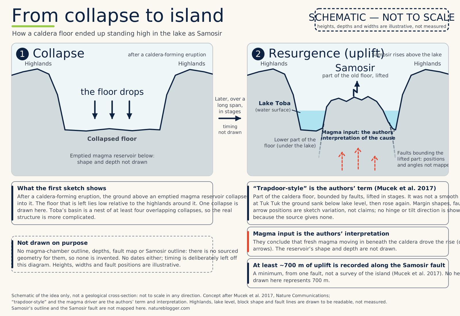
Text description of this figure
Schematic, not to scale. Two cross-section sketches side by side. Left, 1 Collapse: after a caldera-forming eruption the ground above an emptied magma reservoir collapses, leaving a floor that lies low between the surrounding highlands; reservoir shape and depth are not drawn. Right, 2 Resurgence (uplift): part of that floor, bounded by faults, has been lifted in stages, described by the authors as trapdoor-style uplift, and now stands above the lake as Samosir; fresh magma moving in beneath is shown as dashed open arrows because it is the authors' interpretation. A stuttering arrow shows that uplift was episodic, not a smooth climb; a text note says that at Tuk Tuk the ground sank below lake level and later rose again. One collapse is drawn, but a note says the basin of Toba holds at least four overlapping collapses. A text note says uplift of at least about 700 metres is recorded along the Samosir fault, a minimum from one fault; no height drawn is scaled to it. Fault positions, margin shapes, depths and heights are illustrative, and no dates are shown.
So the landscape is not a hole plus an island. It is a collapsed floor and a part of that floor that came back up, with the lake filling the difference.
How big, and how anyone knows
Nobody measured the eruption. Its size has to be rebuilt from what remains: how thick the ash is where we can dig through it, how far that ash reaches, and how much rock now fills the valleys of Sumatra.
The most recent reconstruction, by Costa and colleagues in 2014, put the ash that fell at about 8,600 cubic kilometres. That is a bulk figure, meaning the volume of the loose, airy ash as it lay. Squash it back to solid rock with no gaps and the volume drops to about 3,800 cubic kilometres. Volcanologists call that the dense rock equivalent, or DRE, and it is the fair way to compare eruptions, because loose ash is mostly air. Add about 1,500 cubic kilometres (DRE) of pyroclastic flow deposits, the fast-moving avalanches of hot ash and gas that filled the valleys near the source, and the total comes to about 5,300 cubic kilometres DRE.
A number that size slides off the mind, so here is one way to hold it. On the central estimate, 5,300 cubic kilometres of solid rock is a cube about 17 kilometres along each edge, with every edge roughly twice the height of Mount Everest.
Against another Indonesian eruption, the comparison is sharper. Tambora, in 1815, is estimated at about 41 cubic kilometres DRE (give or take 4). On Costa's central figure, Toba's eruption was roughly 130 times larger. Both numbers are DRE, which is what makes the comparison fair.
Volcanologists also rank eruptions on the Volcanic Explosivity Index, where each step up represents about ten times more erupted material. The YTT is classed at the top, VEI 8. The index uses bulk volumes rather than DRE, so its numbers shouldn't be mixed with the ones above.
Now the caution. "About 5,300" is the best recent single estimate, not a settled fact. An earlier estimate of the ash alone was about half as large, and some were smaller still. Costa's own plausible range stretches from roughly 2,000 to 6,000 cubic kilometres. Across that range, the eruption was somewhere between about 50 and 150 times Tambora. The exact figure keeps moving as researchers add thickness measurements. The more useful thing to take away is the order of magnitude: thousands of cubic kilometres, more than a hundred Tamboras at the upper end, and still dozens at the lower.
The timing is a different story. It is known far better than the size.
In 2012, Storey and colleagues dated sanidine crystals from Toba ash in the Lenggong Valley in Malaysia, 350 kilometres from the source, by measuring how much argon had built up from radioactive decay. They got 73,880 years, give or take 320 (one standard deviation). That was an order of magnitude more precise than earlier estimates. Sulfur in Antarctic ice later placed the best candidate signals between 73,650 and 73,770 years ago. That is consistent with the argon age, but it is not a separate dating: the ice-core team chose candidate peaks that span the argon uncertainty window, then used sulfur isotopes to narrow them.
That is an odd imbalance. The eruption's date is pinned to about 300 years (one standard deviation) out of 74,000, well under one per cent. Its size is uncertain by a factor of about three.
What the ash carries
The YTT ash went a very long way. By Costa's model, more than 5 millimetres of it fell across roughly 40 million square kilometres, from the Arabian Sea in the north-west to the South China Sea in the east. That is about 8 per cent of Earth's surface, or around five Australias.
It matters how that number was made. It comes from a dispersion model tuned to a few dozen thickness measurements, not from a survey of the whole footprint. The shape of it, stretched by the winds of the time, is an inference. Anyone drawing it as a solid blob is drawing the model.
What is measured are the sites where ash has actually been found. Glass shards from Toba have been recovered from sediment cores in Lake Malawi, more than 7,000 kilometres from Sumatra. They have been found in archaeological layers in India and Malaysia. And they turn up at Pinnacle Point and Vleesbaai on South Africa's south coast, where the glass was identified by its chemical fingerprint. Volcanic glass from one eruption has a composition distinct from the next, so a shard a few hundredths of a millimetre across can be traced to its source.
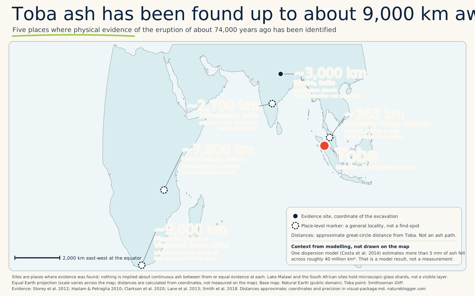
Text description of this figure
Map centred on Toba, Sumatra. Five places where ash or volcanic glass from the Toba eruption about 74,000 years ago has been identified, with approximate great-circle distances from Toba: Lenggong Valley, Malaysia, about 365 km; Jwalapuram, India, about 2,700 km; Dhaba, India, about 3,000 km; Lake Malawi cores, about 7,300 km; Pinnacle Point and Vleesbaai, South Africa, about 9,000 km. Dhaba holds only a few shards and contamination cannot be ruled out. Distances are straight geographic distances, not ash paths. A text note says one dispersion model estimated more than 5 millimetres of ash over roughly 40 million square kilometres; that is a model result, not a measurement, and is not drawn.
The ash also works as a clock. Every place it fell, it fell in the same moment of geological time. A layer found in a Malaysian valley, a Malawian lake core, a South African cave and a Greenland ice core (by a different route, through its chemistry) can be tied together, even though none of those records share a calendar. Storey's paper is titled as a "global synchronization of late Quaternary records". One dated layer lets researchers ask a question across continents: what was happening in each place at that same moment?
What it did to the sky
Ash falls out of the air within days or weeks. Climate is governed by something less visible: sulfur. When a large eruption pushes sulfur dioxide into the stratosphere, it forms a haze of sulfate droplets that reflects sunlight and can cool the surface for years.
For Toba, the evidence is in polar ice. Crick and colleagues, in 2021, measured sulfur isotopes in two Antarctic cores, across 11 candidate Toba sulfate peaks. Their key observation is a signature called mass-independent fractionation, which shows up in sulfur that was exposed to ultraviolet light, meaning it reached a height where the ozone layer no longer shields it. The strongest candidate carries the largest signal of that kind ever reported in polar volcanic sulfate. From it they infer that the plume may have climbed higher than 45 kilometres, though they describe that step from signal to height as tentative.
Their estimate of the sulfur that reached the stratosphere, scaled up from what was deposited in the ice, is 154 to 233 teragrams for the leading candidates. A teragram is a million tonnes, so that is 154 to 233 million tonnes of sulfur, about two to four times that of the 1257 Samalas eruption in Indonesia and about five and a half to eight times Tambora's.
The timing is where the story gets interesting. Earlier work had noticed a large sulfate peak in Greenland ice in the middle of a cold interval, and it was natural to read the cold as Toba's doing. Crick's results place the best candidate peaks at the transition into Greenland Stadial 20, a long cold spell. Their conclusion is careful: Toba was not the trigger for the northern cooling, although they cannot rule out that it amplified a cooling already under way. The dramatic ice-core temperature drop often quoted alongside Toba is a Greenland figure, and its link to the eruption is now in doubt.
So how much cooling did Toba cause? Climate models give a range, and the range is the point. Estimates of how much sulfur dioxide the eruption released span about two orders of magnitude, from roughly 70 to 6,600 teragrams. Black and colleagues, in 2021, ran ensembles of climate simulations with 200 and 2,000 teragrams of sulfur dioxide. Global mean cooling at its peak came out between about 2.3 degrees Celsius (200 teragrams) and 4.1 (2,000 teragrams), reaching its maximum between six months and two and a half years after the eruption. In the 2,000-teragram case, the global mean stayed more than 2 degrees cooler for up to five years. Some earlier models gave much larger numbers until researchers allowed the sulfate droplets to grow. Bigger droplets fall out faster and reflect less, which cuts the cooling, and their real size is one of the unknowns.
The regional picture matters as much as the average. In those simulations the response was pronounced across Europe, North America and central Asia, and muted in the Southern Hemisphere, where even in the most severe scenario cooling was unlikely to exceed 4 degrees Celsius. "Muted" is relative. The authors' own summary puts Northern Hemisphere cooling in the severe scenarios at at least 4 degrees, and regionally as high as 10. These are model outputs, not observations.
Taken together: a very large, high-reaching sulfur injection is well supported. Models say it cooled the planet for years. How much, where, and whether it helped tip Greenland into a long cold spell, are questions the evidence has not settled.
The story that stuck
The idea that Toba nearly finished us has a traceable history. The science journalist Ann Gibbons raised the link in 1993. In 1998 the anthropologist Stanley Ambrose set out the fullest version: Toba's volcanic winter, he argued, could have cut human numbers drastically, and may have left populations small enough for founder effects and rapid divergence between groups. Later summaries often put the survivors at perhaps ten thousand or fewer, though accounts of the figure differ and some give 3,000 to 10,000 breeding individuals. Volcanologists including Michael Rampino and Stephen Self lent support.
It was a reasonable idea given what was known. Living humans show surprisingly little genetic diversity, and some genetic analyses seemed to show a population dip at a compatible time. And the dating of the eruption was loose enough, before 2012, that it and a genetic signal could plausibly coincide. One event explained the geology and the genes at once.
That is the pull of a good hypothesis. It made predictions, and predictions can be tested.
Testing the story
If an eruption crashed human numbers, three things should show up. The climate should have turned harsh where people lived. People should disappear or change abruptly in the record after the ash. And the genes should show a dip at about 74,000 years ago.
The climate check began in Lake Malawi. Lane and colleagues, in 2013, found the Toba ash in cores from the lake's floor, more than 7,000 kilometres from Sumatra, and looked at what the sediments did around it. They found no major change in composition and no evidence of substantial temperature change. Their conclusion was that the eruption did not significantly affect East Africa's climate and was not the cause of a human genetic bottleneck. It is one lake, and other work has found some effect on mountain vegetation. A 2026 study by Park and colleagues of varved sediments from Lake Chala, below Kilimanjaro on the Kenya–Tanzania border, resolved change year by year and suggests something between the two: modest cooling and an acute drought lasting less than two years, on top of a longer cooling and drying trend. It is again a single site, and because Lane is among its authors it refines the Malawi result rather than independently replicating it. On that record, Toba was a real, short disturbance, not a collapse.
The harsher local picture comes from India. At Jwalapuram, a study published in 2025 read six annual cycles in the ash layer and reported about a year of muted cooling followed by roughly four years of warming and drought at that site. It is a single site and has not yet been replicated, but it is a reminder that "no global catastrophe" does not mean "nothing happened anywhere".
Next, archaeology. At Pinnacle Point and Vleesbaai, the shards sit in the sediment layers themselves, so the ash can be tied to a specific moment of occupation. The team, Smith and colleagues in 2018, reports continuous occupation across the ash and tool-making innovations afterwards. At Dhaba, in central India, Clarkson and colleagues (2020) found a stone tool industry that did not change across the eruption. Its dating is broad, bracketed between about 79,600 and 65,200 years ago, and the authors conclude only that similar technology was present before and after. At Jwalapuram, earlier excavations found tools above and below the ash with striking continuity.
Each of these is a single site, and several are coastal or otherwise favourable places. A shard in a cave shows that people were living there. It does not show that everyone was.
Then the genes. Whole-genome analyses place the major dips elsewhere: a possible decline some 150,000 to 130,000 years ago, and a founder effect of about 50,000 years ago, associated with small groups leaving Africa. As one widely cited review summarises, numerous genetic analyses have not detected a bottleneck that coincides with Toba. Low diversity, meanwhile, can be explained by long-term small populations without a single catastrophe.
Where does that leave the claim? The Toba catastrophe hypothesis, as a global crash in human numbers, is no longer supported by the evidence. That is not the same as disproven for every group of people everywhere, and genetics alone cannot settle it: the methods have limited resolution for a short bottleneck. The conclusion rests on climate, archaeology and genetics pointing the same way. Local conditions may have been severe where ash fell thickest, and archaeological sites are survivors' records: the ash can show where people were, but it can't show who wasn't.
One more thing to keep apart. A different bottleneck claim turns up in the same conversations: a 2023 paper argued for a severe ancestral bottleneck between about 930,000 and 813,000 years ago. That is some 800,000 years before Toba, and it has no connection to it. It is also contested: critics in 2025 say the data do not support it, and the original authors have replied and maintain their conclusion. Two "human bottleneck" stories, neither of them a Toba story, and one of them still being argued.
A volcano after the volcano
The end of the YTT was not the end of Toba. Post-eruption activity, Mucek's team found, started soon after the climactic eruption and continued in bursts for at least 15,000 years, give or take 9,000. Lava domes on Samosir and around Pusuk Buhit on the lake's west side date from about 69,700 down to about 54,500 years ago. The resurgence that raised Samosir continued until at least 2,700 years ago.
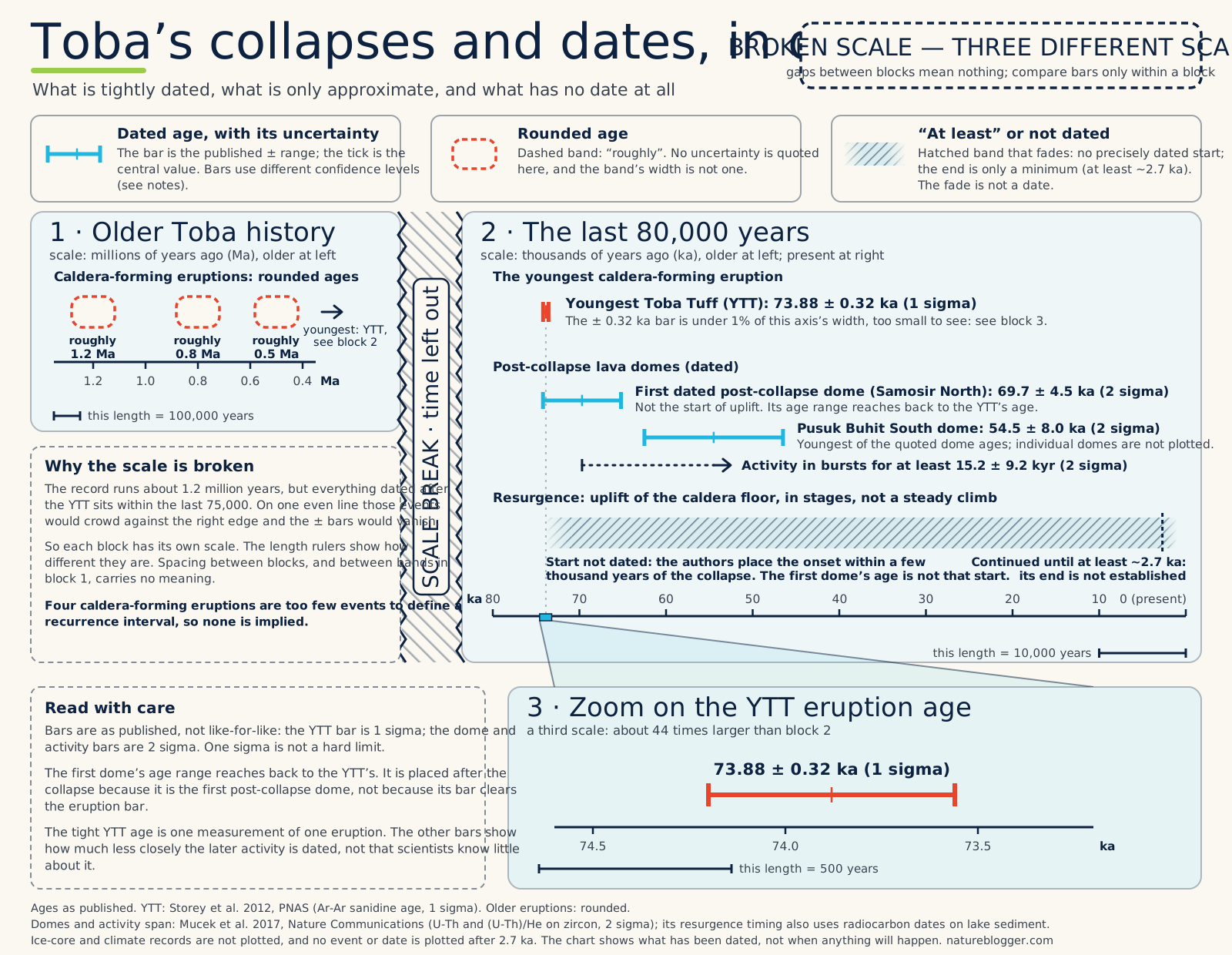
Text description of this figure
Broken-scale timeline in three blocks, each on its own scale; distances between blocks mean nothing. Block 1, millions of years: earlier caldera-forming eruptions at roughly 1.2, 0.8 and 0.5 million years ago, drawn as dashed bands because the ages are rounded and no uncertainty is quoted. Block 2, the last 80,000 years: the Youngest Toba Tuff eruption at 73.88 plus or minus 0.32 thousand years ago (one sigma), a bar under one per cent of the axis width at that scale; the first dated post-collapse lava dome at 69.7 plus or minus 4.5 thousand years ago (two sigma), whose range reaches back to the eruption age; a lava dome at 54.5 plus or minus 8.0 thousand years ago (two sigma), with a dashed span for post-eruption activity that continued in bursts for at least about 15 thousand years, give or take 9 thousand. Resurgence, the uplift of the caldera floor, is a hatched band that fades in with no start date, because its onset is not dated (the authors place it within a few thousand years of the collapse, and the first dome is not its start), and fades out shortly after 2.7 thousand years ago, because its end is not established; the fade is not a date and does not mean it stopped or is still going. Block 3 magnifies the eruption age on a third scale. The bars use different confidence levels, one sigma for the eruption and two sigma for the domes. No ice-core or climate record is plotted, no event or date is plotted after 2.7 thousand years ago, and no recurrence or forecast is implied.
The magma system beneath all this is more than a cavern. Seismic imaging suggests a stack of partly molten layers beneath about 7 kilometres of rock, which is hard to show as a neat cutaway. Geochemically, the same team concluded that the system extends about 30 kilometres north to Sinabung, a separate active volcano that has been erupting in recent years, and that Sinabung's eruptions are tapping it. That is an inference from chemistry, and it is why Sinabung is sometimes confused with Toba: they share a signature. Sinabung erupts. The caldera itself, as far as the record shows, does not.
A 2021 modelling study by Liu and colleagues gives a sense of the scale of what remains. If melt kept flowing in at the average rate of the past 2.2 million years, there is now a minimum of about 315 cubic kilometres of magma that could in principle be erupted, and it is accumulating at a minimum of about 4.2 cubic kilometres every thousand years. Both are modelled minimums. They describe a system, not a timetable.
What nobody can tell you about the next one
Toba is usually called a supervolcano. The term is informal; it generally means a volcano that has produced at least one supereruption, roughly VEI 8. It describes Toba's history. It isn't a description of Toba's current condition, and it says nothing about when, or whether, another one will come.
The Smithsonian Global Volcanism Program, the standard catalogue, records no known eruption of Toba in the past 10,000 years. That is a statement about the record, not a guarantee, and not a statement about what the volcano is doing today. The same catalogue notes that Tandukbenua, a volcano on the caldera's north-west rim, may be only a few hundred years old, an age attributed to Chesner and Rose (1991) and not firmly dated. This article doesn't report Toba's current status. For that, the sources are Indonesia's geological agency, including its MAGMA Indonesia service, and the GVP. NatureBlogger's own live volcano page covers US-monitored volcanoes only, so Toba isn't on it.
As for a countdown, there is no defensible forecast. Four caldera-forming eruptions over 1.2 million years are too few events to define a recurrence interval, and the 2021 modelling found that a surge in magma supply isn't necessarily required before a supereruption, which means the absence of a surge isn't reassurance either. Claims of the form "due in X years" go beyond what the evidence supports, and this is not a prediction in either direction.
What is still open
A few things remain unsettled, and they are the interesting ones. Whether Toba sulfur helped set off, or merely coincided with, the long cold spell in Greenland. How big the droplets grew, which decides how much of the modelled cooling is real. How harsh the local conditions were where the ash was thickest, and whether Jwalapuram's warming and drought holds up elsewhere. And how much melt the system holds now, a question that the best current answer can only bound from below.
The eruption's date is known to about 300 years either way (one standard deviation). What it did is still argued about.
Sources and method
Numbers in this feature come from these sources, and each carries a class: measured (directly dated or observed), estimated (reconstructed from sparse data), inferred (a model or an interpretation) or debated (published estimates disagree). Research date: 1 October 2026.
- Age: Storey, Roberts & Saidin 2012, PNAS (measured); Crick et al. 2021, Climate of the Past (measured/inferred). The ice-core candidates are consistent with the radiometric age but are not an independent dating, because the team selected candidate peaks that span the argon uncertainty window.
- Volume and ash: Costa, Smith, Macedonio & Matthews 2014, Frontiers in Earth Science (estimated; modelled ash extent). Tambora: Kandlbauer & Sparks 2014, Journal of Volcanology and Geothermal Research (estimated). The 17-kilometre cube, the 130-times and 50-to-150-times ratios, and the 8 per cent and "five Australias" figures are our own arithmetic on those numbers.
- Distances: the Malawi distance is from Lane et al. 2013; the roughly 9,000 kilometres to Mossel Bay is our calculation of the great-circle distance, not a figure from the source paper.
- Caldera, Samosir and post-eruption activity: Mucek et al. 2017, Nature Communications (dated; interpretive). "Trapdoor-style" is the authors' own term. The 69,700-year age is that of the earliest post-collapse lava dome, not a measured start date for uplift.
- Magma system: Liu et al. 2021, PNAS (inferred; modelled minimums); Jaxybulatov et al. 2014, Science (inferred).
- Climate: Crick et al. 2021 (sulfur loadings are scaled from sulfur deposited in the ice; Tambora's roughly 28 million tonnes of sulfur is Self 2004, as cited by Crick); Black et al. 2021, PNAS (inferred; model-dependent; the Northern Hemisphere figures are from the authors' public statement, as we did not open the full text); earlier models by Robock et al. 2009 and Timmreck et al. 2010 (inferred).
- Human evidence: Lane et al. 2013, PNAS; Park et al. 2026, Science Advances 12(31) (Lake Chala, a single site; read as abstract); Smith et al. 2018, Nature (abstract and institutional release); Clarkson et al. 2020, Nature Communications; Jwalapuram work (2025, PNAS Nexus). The history of the bottleneck hypothesis, Ambrose's argument, Petraglia and Haslam's Jwalapuram excavations, the genetic literature and the critiques of and reply to Hu et al. 2023 are taken from abstracts, published reviews and summaries (John Hawks, 2018; a review in Mondes Préhistoriques); we have not re-read the original papers.
- Eruptive record: Smithsonian Global Volcanism Program (Toba, volcano 261090), including its note on Tandukbenua (reported to us, not opened directly).
What we could not open: the GVP page itself, the full text of several Nature and Science papers (including Park et al. 2026) and the full text of Black et al. 2021 were inaccessible to us, so some statements rely on abstracts, institutional summaries or review articles, as noted above. Figures will change as research does.